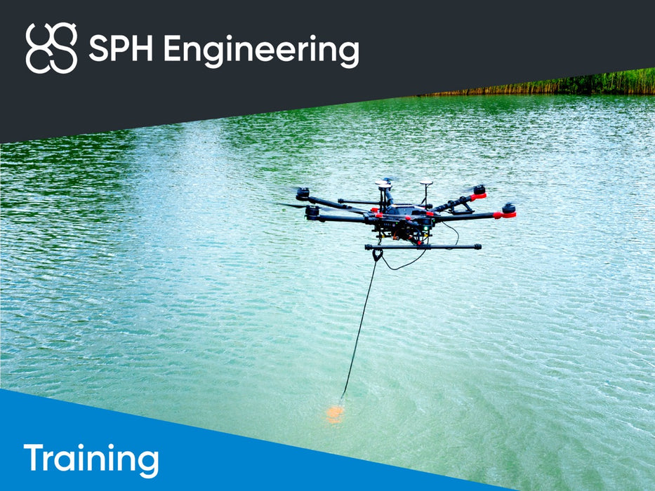
Skip to content
Introducing UgCS Open -> Free Flight Planning -> Download Now!
Download UgCS Open-> Try Free Flight Planning!

Trainer-led course - Bathymetric Data Collection using Drones (BATHY-1)

SKU IS-TRAINING-BATHY-1
Original price 865.00 USD - Original price 865.00 USD
Original price
865.00 USD
865.00 USD - 865.00 USD
Current price 865.00 USD

Only one of its kind training to learn how to perform bathymetric surveys with echo sounders integrated with a drone.

Students should have the knowledge and practical experience covered by training:

Can be provided at the SPH Engineering office or using video conferencing software.

Duration: up to 4 hours.

The price is for a group of up to 4 students.

Prerequisites:

Completed UgCS AreaScan and True Terrain following missions training or equivalent knowledge and experience.

Trainee has to perform True Terrain Following mission test flight over the ground in safe and controlled environment. Remote review of telemetry and SkyHub positioning log files will be performed at the beginning of the session. If a trainee can't demonstrate results of completed missions, the trainer will cancel the training session, and it has to be rescheduled.

Training outline:

  • Safety considerations for flights over water
  • System assembly
  • System parameters setup (echo sounder mode, data logging formats, angles, etc.)
  • Planning the survey grid for bathymetric surveys
  • Grasshopper mode for bathymetric surveys
  • Quality control (control lines, etc.)

---

All prices without VAT/tax. VAT is calculated during checkout depending on your provided billing data.

{"id":8489870590297,"title":"Trainer-led course - Bathymetric Data Collection using Drones (BATHY-1)","handle":"training-bathy-1","description":"\u003cp\u003eOnly one of its kind training to learn how to perform bathymetric surveys with echo sounders integrated with a drone.\u003cbr data-mce-fragment=\"1\"\u003e\u003cbr data-mce-fragment=\"1\"\u003eStudents should have the knowledge and practical experience covered by training:\u003cbr\u003e\u003c\/p\u003e\n\u003cul\u003e\n\u003cli\u003e\u003ca href=\"https:\/\/shop.sphengineering.com\/products\/training-ugcs-basics\"\u003eUgCS Basics\u003c\/a\u003e\u003c\/li\u003e\n\u003cli\u003e\u003ca href=\"https:\/\/shop.sphengineering.com\/products\/training-ugcs-areascan-and-true-terrain-following-missions\"\u003eUgCS AreaScan and True Terrain Following Missions\u003c\/a\u003e\u003c\/li\u003e\n\u003c\/ul\u003e\n\u003cp\u003eCan be provided at the SPH Engineering office or using video conferencing software.\u003cbr\u003e\u003c\/p\u003e\n\u003cp\u003eDuration: up to 4 hours.\u003cbr\u003e\u003c\/p\u003e\n\u003cp\u003eThe price is for a group of up to 4 students.\u003c\/p\u003e\n\u003cp\u003e\u003cstrong\u003ePrerequisites:\u003c\/strong\u003e\u003c\/p\u003e\n\u003cp data-mce-fragment=\"1\"\u003eCompleted \u003ca href=\"https:\/\/shop.sphengineering.com\/products\/training-ugcs-areascan-and-true-terrain-following-missions\" data-mce-href=\"https:\/\/shop.sphengineering.com\/products\/training-ugcs-areascan-and-true-terrain-following-missions\"\u003eUgCS AreaScan and True Terrain following missions\u003c\/a\u003e training\u003cspan\u003e \u003c\/span\u003eor equivalent knowledge and experience.\u003c\/p\u003e\n\u003cp data-mce-fragment=\"1\"\u003e\u003cspan\u003eTrainee \u003cspan style=\"text-decoration: underline;\"\u003ehas to\u003c\/span\u003e perform True Terrain Following mission test flight over the ground in safe and controlled environment. Remote review of telemetry and \u003c\/span\u003e\u003cspan color=\"#ff0000\" style=\"color: #000000;\" data-mce-style=\"color: #000000;\"\u003eSkyHub\u003c\/span\u003e\u003cspan\u003e\u003cspan style=\"color: #000000;\" data-mce-style=\"color: #000000;\"\u003e \u003c\/span\u003epositioning log files will be performed at the beginning of the session. \u003c\/span\u003e\u003cspan\u003eIf a trainee can't demonstrate results of completed missions, the trainer will cancel the training session, and it has to be rescheduled.\u003c\/span\u003e\u003c\/p\u003e\n\u003cp\u003e\u003cstrong\u003eTraining outline:\u003c\/strong\u003e\u003c\/p\u003e\n\u003cul\u003e\n\u003cli\u003eSafety considerations for flights over water\u003c\/li\u003e\n\u003cli\u003eSystem assembly\u003c\/li\u003e\n\u003cli\u003eSystem parameters setup (echo sounder mode, data logging formats, angles, etc.)\u003c\/li\u003e\n\u003cli\u003ePlanning the survey grid for bathymetric surveys\u003c\/li\u003e\n\u003cli\u003eGrasshopper mode for bathymetric surveys\u003c\/li\u003e\n\u003cli\u003eQuality control (control lines, etc.)\u003c\/li\u003e\n\u003c\/ul\u003e","published_at":"2023-08-10T12:19:08+03:00","created_at":"2023-08-10T12:11:13+03:00","vendor":"SPH Engineering","type":"course","tags":["Bathymetry","Bathymetry_training","Integrated Systems_Bathymetry training"],"price":86500,"price_min":86500,"price_max":86500,"available":true,"price_varies":false,"compare_at_price":null,"compare_at_price_min":0,"compare_at_price_max":0,"compare_at_price_varies":false,"variants":[{"id":47005550051673,"title":"Default Title","option1":"Default Title","option2":null,"option3":null,"sku":"IS-TRAINING-BATHY-1","requires_shipping":false,"taxable":true,"featured_image":null,"available":true,"name":"Trainer-led course - Bathymetric Data Collection using Drones (BATHY-1)","public_title":null,"options":["Default Title"],"price":86500,"weight":0,"compare_at_price":null,"inventory_management":null,"barcode":null,"requires_selling_plan":false,"selling_plan_allocations":[]}],"images":["\/\/shop.sphengineering.com\/cdn\/shop\/files\/2023_10_SPH_Engineering_shop_Integrated_Systems_TRAININGS.jpg?v=1700814313"],"featured_image":"\/\/shop.sphengineering.com\/cdn\/shop\/files\/2023_10_SPH_Engineering_shop_Integrated_Systems_TRAININGS.jpg?v=1700814313","options":["Title"],"media":[{"alt":null,"id":44496070738265,"position":1,"preview_image":{"aspect_ratio":1.333,"height":900,"width":1200,"src":"\/\/shop.sphengineering.com\/cdn\/shop\/files\/2023_10_SPH_Engineering_shop_Integrated_Systems_TRAININGS.jpg?v=1700814313"},"aspect_ratio":1.333,"height":900,"media_type":"image","src":"\/\/shop.sphengineering.com\/cdn\/shop\/files\/2023_10_SPH_Engineering_shop_Integrated_Systems_TRAININGS.jpg?v=1700814313","width":1200}],"requires_selling_plan":false,"selling_plan_groups":[],"content":"\u003cp\u003eOnly one of its kind training to learn how to perform bathymetric surveys with echo sounders integrated with a drone.\u003cbr data-mce-fragment=\"1\"\u003e\u003cbr data-mce-fragment=\"1\"\u003eStudents should have the knowledge and practical experience covered by training:\u003cbr\u003e\u003c\/p\u003e\n\u003cul\u003e\n\u003cli\u003e\u003ca href=\"https:\/\/shop.sphengineering.com\/products\/training-ugcs-basics\"\u003eUgCS Basics\u003c\/a\u003e\u003c\/li\u003e\n\u003cli\u003e\u003ca href=\"https:\/\/shop.sphengineering.com\/products\/training-ugcs-areascan-and-true-terrain-following-missions\"\u003eUgCS AreaScan and True Terrain Following Missions\u003c\/a\u003e\u003c\/li\u003e\n\u003c\/ul\u003e\n\u003cp\u003eCan be provided at the SPH Engineering office or using video conferencing software.\u003cbr\u003e\u003c\/p\u003e\n\u003cp\u003eDuration: up to 4 hours.\u003cbr\u003e\u003c\/p\u003e\n\u003cp\u003eThe price is for a group of up to 4 students.\u003c\/p\u003e\n\u003cp\u003e\u003cstrong\u003ePrerequisites:\u003c\/strong\u003e\u003c\/p\u003e\n\u003cp data-mce-fragment=\"1\"\u003eCompleted \u003ca href=\"https:\/\/shop.sphengineering.com\/products\/training-ugcs-areascan-and-true-terrain-following-missions\" data-mce-href=\"https:\/\/shop.sphengineering.com\/products\/training-ugcs-areascan-and-true-terrain-following-missions\"\u003eUgCS AreaScan and True Terrain following missions\u003c\/a\u003e training\u003cspan\u003e \u003c\/span\u003eor equivalent knowledge and experience.\u003c\/p\u003e\n\u003cp data-mce-fragment=\"1\"\u003e\u003cspan\u003eTrainee \u003cspan style=\"text-decoration: underline;\"\u003ehas to\u003c\/span\u003e perform True Terrain Following mission test flight over the ground in safe and controlled environment. Remote review of telemetry and \u003c\/span\u003e\u003cspan color=\"#ff0000\" style=\"color: #000000;\" data-mce-style=\"color: #000000;\"\u003eSkyHub\u003c\/span\u003e\u003cspan\u003e\u003cspan style=\"color: #000000;\" data-mce-style=\"color: #000000;\"\u003e \u003c\/span\u003epositioning log files will be performed at the beginning of the session. \u003c\/span\u003e\u003cspan\u003eIf a trainee can't demonstrate results of completed missions, the trainer will cancel the training session, and it has to be rescheduled.\u003c\/span\u003e\u003c\/p\u003e\n\u003cp\u003e\u003cstrong\u003eTraining outline:\u003c\/strong\u003e\u003c\/p\u003e\n\u003cul\u003e\n\u003cli\u003eSafety considerations for flights over water\u003c\/li\u003e\n\u003cli\u003eSystem assembly\u003c\/li\u003e\n\u003cli\u003eSystem parameters setup (echo sounder mode, data logging formats, angles, etc.)\u003c\/li\u003e\n\u003cli\u003ePlanning the survey grid for bathymetric surveys\u003c\/li\u003e\n\u003cli\u003eGrasshopper mode for bathymetric surveys\u003c\/li\u003e\n\u003cli\u003eQuality control (control lines, etc.)\u003c\/li\u003e\n\u003c\/ul\u003e"}