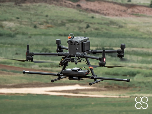
Integrated Systems
Expand your drone capabilities with SPH Engineering's professional integrated systems; the most comprehensive solution for advanced sensor integration and data collection. Our SkyHub onboard computer serves as the central nervous system, enabling seamless integration of diverse sensors with professional UAV platforms while maintaining complete data security and operational reliability.
Designed for professionals in geophysical surveying, hydrographic operations, environmental monitoring, and archaeological research, our integrated systems combine industry-leading sensors with specialized UAV integration. From ground penetrating radar to magnetometers, methane detectors to echo sounders, each system is engineered for precision data collection in challenging environments where traditional methods fall short.
-

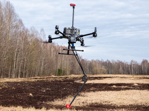
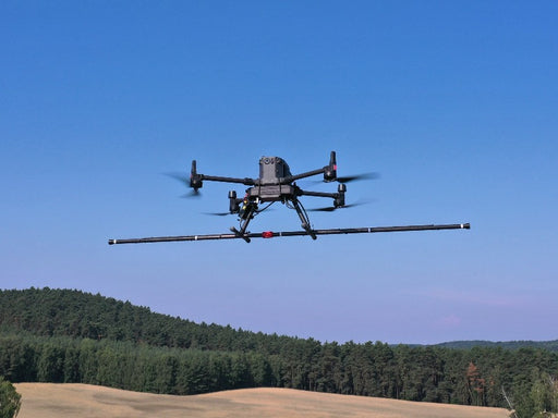
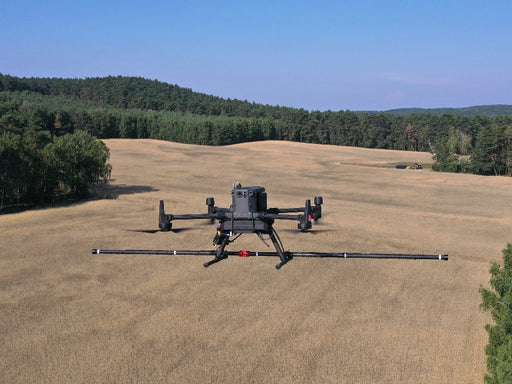
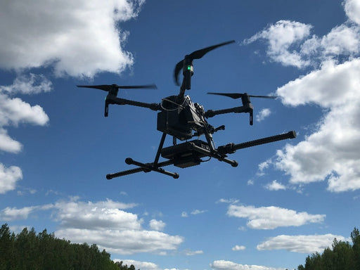
MagNIMBUS atomic total-field magnetometer
SPH EngineeringUltra-sensitive airborne integrated magnetometer system powered by QuSpin QTFM Gen-2 atomic total-field magnetometer sensors Unique system design a...
View full details -
SENSYS MagDrone R4 magnetometer
SENSYSThe MagDrone R4 is an ultra light weight magnetometer with 5 triaxial Fluxgates to be attached to any UAV capable to carry 2 kg of payload. In oppo...
View full details -
SENSYS MagDrone R3 magnetometer
SENSYSThe MagDrone R3 is an ultra portable magnetometer to be attached to any UAV with a minimum payload of 1kg. MagDrone R3 (starting from SN SN000200) ...
View full details -


SENSYS MagDrone R1 magnetometer
SENSYSThe MagDrone R1 is an ultra portable magnetometer to be attached to any UAV with a minimum payload of 1kg. Unique system design allows to fly with ...
View full details -
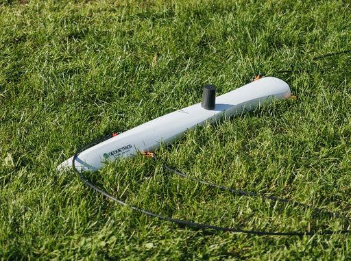
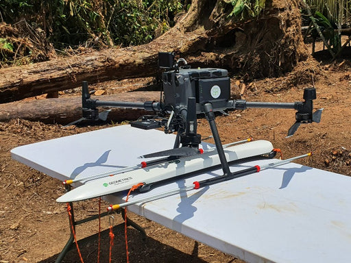
Geometrics MagArrow Mk2 magnetometer
GeometricsThe MagArrow II is the second generation of Geometrics best-selling magnetometer. MagArrow is fully self-contained sensor (with build-in GPS receiv...
View full details -
 Original price 475.00 USD - Original price 475.00 USDOriginal price 475.00 USD475.00 USD475.00 USD - 475.00 USDCurrent price 475.00 USD
Practical Exam & Certification - Magnetometer
LearnWorldsThe test verifies hands-on skills and experience in gathering, processing, and understanding data using systems provided by SPH Engineering. How it...
View full detailsOriginal price 475.00 USD - Original price 475.00 USDOriginal price 475.00 USD475.00 USD475.00 USD - 475.00 USDCurrent price 475.00 USD -
 Original price 1,553.00 USD - Original price 1,553.00 USDOriginal price1,553.00 USD1,553.00 USD - 1,553.00 USDCurrent price 1,553.00 USD
Trainer-led course - Basics of Magnetic Data Processing and Interpretation
SPH EngineeringOne-of-a-kind training on processing magnetic data collected using drone-mounted magnetometers. The training is for data processing using GeoHammer...
View full detailsOriginal price 1,553.00 USD - Original price 1,553.00 USDOriginal price1,553.00 USD1,553.00 USD - 1,553.00 USDCurrent price 1,553.00 USD -

 Original price 2,964.00 USD - Original price 2,964.00 USDOriginal price2,964.00 USD2,964.00 USD - 2,964.00 USDCurrent price 2,964.00 USD
GeoHammer Pro data processing software
SPH EngineeringSPH Engineering's GeoHammer is a simple to use tool to quickly assess and process GPR (ground penetrating radar) and CSV data from various sensors ...
View full detailsOriginal price 2,964.00 USD - Original price 2,964.00 USDOriginal price2,964.00 USD2,964.00 USD - 2,964.00 USDCurrent price 2,964.00 USD -

GeoHammer data processing software (free version)
SPH EngineeringDownload GeoHammer SPH Engineering's GeoHammer is a simple-to-use tool to quickly assess and process GPR (ground penetrating radar) and CSV dat...
View full details -
GeoHammer Pro data processing software (cloud access)
SPH EngineeringGeoHammer Pro is available not only for download and installation, but also from the cloud on a pay-as-you-go basis. Access GeoCloud SPH Engine...
View full details -

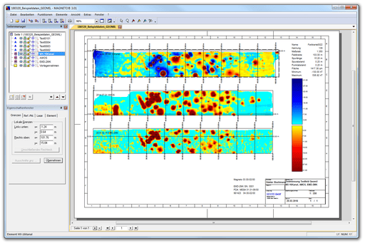
Seequent Oasis montaj
Bentley systems12-month named or shared license. Oasis montaj is industry-standard software for geophysicists to process, filter, and model geophysical survey dat...
View full details -

 Original price 6,414.00 USD - Original price 6,414.00 USDOriginal price6,414.00 USD6,414.00 USD - 6,414.00 USDCurrent price 6,414.00 USD
SENSYS MAGNETO® data processing software
SENSYSSENSYS MAGNETO® is a software for the comprehensive analysis and interpretation of data gathered using MagDrone R3, MagDrone R4, or MagDrone R1 mag...
View full detailsOriginal price 6,414.00 USD - Original price 6,414.00 USDOriginal price6,414.00 USD6,414.00 USD - 6,414.00 USDCurrent price 6,414.00 USD -

 Original price 319.00 USD - Original price 319.00 USDOriginal price319.00 USD319.00 USD - 319.00 USDCurrent price 319.00 USD
SENSYS MagDrone R3 plastic mountings for DJI drones
SPH EngineeringCompatible with DJI M300/M350/M400 RTK. Price for the pair of mountings.
Original price 319.00 USD - Original price 319.00 USDOriginal price319.00 USD319.00 USD - 319.00 USDCurrent price 319.00 USD -
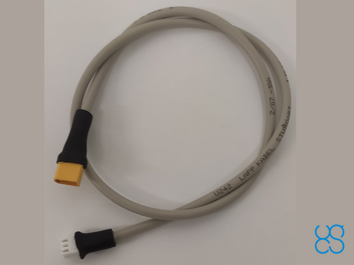 Original price 168.00 USD - Original price 168.00 USDOriginal price168.00 USD168.00 USD - 168.00 USDCurrent price 168.00 USD
SENSYS MagDrone R3 power cable
SPH EngineeringCable to provide power from SkyHub to SENSYS MagDrone R3 magnetometer eliminating the need for an additional battery.Especially convenient when use...
View full detailsOriginal price 168.00 USD - Original price 168.00 USDOriginal price168.00 USD168.00 USD - 168.00 USDCurrent price 168.00 USD -
 Original price 7.00 USD - Original price 7.00 USDOriginal price 7.00 USD25.00 USD25.00 USD - 25.00 USDCurrent price 25.00 USD
Webinar | Magnetic Data Processing with Oasis montaj
LearnWorldsJoin us for a practical online open-class dedicated to magnetic data processing in Oasis montaj. The webinar is designed for professionals and rese...
View full detailsOriginal price 7.00 USD - Original price 7.00 USDOriginal price 7.00 USD25.00 USD25.00 USD - 25.00 USDCurrent price 25.00 USD


