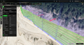
Smart AGL
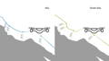
Compared to normal AGL terrain following, Smart AGL allows the drone to keep a constant distance not only to what is below it but also to what is in front of it, increasing flight safety.


Smart AGL
Assists in flying in areas with steep hills, maintaining an exact distance to the nearest surface
More about Smart AGL
Compared to normal AGL terrain following, Smart AGL allows the drone to keep a constant distance not only to what is below it but also to what is in front of it, increasing flight safety.
LiDAR tool
Automatic IMU calibration patterns (L1, L2, 8-figure, u-shape), adjustable corner radius and loop turns
More about LiDAR tool
LiDAR toolset in UgCS allows using any LiDAR sensors, including DJI (L1, L2), YellowScan, Riegl, and others.
Flights can be planned using the FOV angle of the LiDAR. IMU calibration actions (back-and-forth, 8-figure) are inserted inside the automated route, ensuring correct functioning of the IMU and accurate data.
Proper calibration is critical for accurate point clouds. Automated patterns keep your LiDAR data consistent across long corridor scans and multi-battery missions. Pilots save 30+ minutes per flight and eliminate calibration errors that ruin datasets.
Trajectory Smoothing
Adjust slope angles and avoid risky dives. Increase flight safety in LiDAR and magnetometer missions
More about Trajectory Smoothing
Trajectory Smoothing feature allows adjusting the drone glide slope and minimum gaps to skip when flying over terrain with risky dives and steep ascents. Intended for pilots flying magnetometer surveys and LiDAR scans.
Sharp altitude changes stress equipment, drain batteries, and create motion blur in LiDAR and magnetometer data.
UgCS smooths aggressive angles automatically. Your drone stays stable, batteries last longer, and sensors collect clean data.
Digital Surface Models (DSM) Support
Import and visualize digital surface models in the Elevation Profile window and on the map.
More about Digital Surface Models (DSM) Support
Import and visualize high-resolution Digital Surface Models in the Elevation Profile window and on your map. DSMs show buildings, trees, power lines, and obstacles that standard elevation data misses.
Plan flights around real-world structures before you fly. Pilots working corridor mapping, urban inspections, or mining operations get accurate obstacle data and avoid crashes or mission failures.
Route creation from KML / CSV files
More about Route Creation from KML/CSV Files
Import flight paths directly from KML or CSV files. Coordinates from clients, GIS teams, or field coordinators convert into ready-to-fly missions in seconds.
Utility companies, telecoms, and surveying firms use this daily to manage hundreds of kilometers of infrastructure. UgCS builds missions automatically with correct spacing, altitude, and overlap settings. Saves hours of planning.
Exporting routes in KML
Export routes to KML for preview in Google Earth Pro
More about Exporting Routes in KML
Export routes to KML for preview in Google Earth Pro. Review your mission in 3D, share with clients or team members, and verify coverage before heading to the field.
Spot potential issues, confirm flight paths with stakeholders, and make adjustments from the office. No surprises on site.
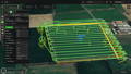
Circlegrammetry tool
Capture 3D models with circular flight patterns for increased accuracy and reduced flight time
More about Circlegrammetry Tool
Capture detailed 3D models using circular flight patterns. Circlegrammetry increases model accuracy and reduces flight time compared to traditional double grid patterns.
Pilots inspecting towers, monuments, silos, or complex structures get complete 360° coverage faster. More angles per flight minute means better models with fewer batteries and less field time.
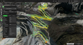
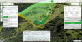
Terrain following
Plan flights with default terrain following or import your own elevation data
More about Terrain Following
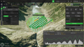
Plan flights with default terrain following using built-in elevation data, or import your own high-resolution DEMs. Your drone maintains a consistent altitude above ground automatically.
Mapping missions require a constant ground sampling distance. Terrain following prevents data gaps and ensures uniform pixel size. Pilots working forestry, agriculture, or large construction sites get usable data on the first flight.
Customisable map
Import your own custom DEM/DSM and map overlays
More about Customizable Map
Import your own custom DEM/DSM files and map overlays. Use up-to-date terrain data, site plans, or specialized maps that match your project needs.
Standard maps don't show recent construction, mining activity, or private property details. Custom overlays give you accurate context for mission planning on active job sites or changing landscapes.
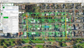
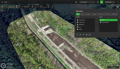
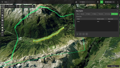
Corridor inspections
Create a long corridor for power line, road, and pipes inspections
More about Corridor Inspections
Create long corridor missions for power lines, roads, pipelines, and rail inspections. Define width, spacing, and altitude. UgCS generates the route automatically.
Plan 200+ km missions from your desktop, include battery changes, and maintain consistent altitude over rolling terrain. Perfect for utility companies and transport authorities running regular inspection programs.
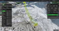
Vertical flight planning
Automate building inspections, import 3d models for facade scan
More about Vertical Flight Planning
Automate building and façade inspections. Import 3D models for precise vertical scans of walls, dams, bridges, and structures.
UgCS plans perpendicular camera angles, maintains constant distance from surfaces, and ensures complete coverage with proper overlap. Pilots inspecting dams, high-rises, or industrial structures get repeatable missions that produce millimeter-resolution 3D models for crack detection and structural analysis.
Go offline
Cache maps and elevation for offline use and plan your flights even in the most remote regions of the world
More about Go Offline
Cache maps and elevation data for offline use. Plan and execute flights in remote regions with limited or no internet connection.
Mining sites, forestry operations, and disaster response missions often happen where cellular coverage doesn't exist. UgCS works completely offline once maps are cached. Plan flights in the field and fly with full functionality anywhere in the world.
Live video streaming
Stream live geotagged video from your drones from anywhere in the world
More about Live Video Streaming
Stream live geotagged video from your drones from anywhere. View real-time footage with location data embedded.
Command centers, remote teams, and clients watch missions as they happen. Pilots flying search and rescue, disaster assessment, or security operations provide instant situational awareness. GPS coordinates are embedded, making it easy to locate findings and direct ground teams.
Supported drones: DJI M300, Mavic 2 Enterprise series, M210, M200, Phantom 4 series.
This feature is not currently available for newer drones such as M350, M3E, M4, M30, M400.
Up to 10 simultaneous drone connections
Connect multiple drones and use them together
More about Up to 10 Simultaneous Drone Connections
UgCS Enterprise allows connecting up to 10 drones simultaneously. Coordinate flight plans in a team of drone pilots and run parallel missions with centralized oversight.
Large-area surveys, search and rescue operations and time-sensitive inspections benefit from multi-drone workflows. Instead of flying one drone four times, fly four drones once. Pilots managing big projects cut field time dramatically.
Share your missions with the team
Set up a centralised UgCS server (locally or in the cloud) and share your routes and drone flight data across the team
More about Share Your Missions with the Team
Set up a centralized UgCS server (locally or in the cloud) and share routes and flight data across your team. Everyone works from the same mission library with version control.
Drone operations with multiple pilots need coordination. Shared missions mean consistent flight plans, no duplicate work, and easy handoffs. Flight telemetry data syncs automatically for review and quality control.
UgCS SDK
Build custom solutions for your needs
More about UgCS SDK
Build custom solutions for your specific workflows. The UgCS SDK gives developers full access to extend functionality and integrate with existing systems.
Specialized operations often need unique features. Integrate proprietary sensors, connect to enterprise software, or automate complex workflows. Companies with internal development teams can build exactly what they need.
Full 3D desktop flight planning
Create drone missions of any complexity from the comfort of your home or office while ensuring flight safety
Elevation model import
Use default terrain data or easily import and store your own digital elevation models. Adjust the resolution of terrain following to optimize your flight plan for any scenario
LiDAR toolset
Leverage UgCS` LiDAR toolset to get the most out of your surveys. Automated IMU calibrations, loop turns, adjustable corner radius and area buffer and more

Supporting Your Drone Fleet
We support a wide range of drone models, making it the perfect choice for diverse fleets

Supportive Community
Community where you can share insights, ask questions, and collaborate with fellow users
Support You Can Rely On
Contact us for any reason at support@ugcs.com and we'll respond within 1 business day
!!! However, it is still recommended to have the laptop with you in the field in case any modifications or adjustments of the route need to be done.