Integrated Systems
Expand your drone capabilities with SPH Engineering's professional integrated systems; the most comprehensive solution for advanced sensor integration and data collection. Our SkyHub onboard computer serves as the central nervous system, enabling seamless integration of diverse sensors with professional UAV platforms while maintaining complete data security and operational reliability.
Designed for professionals in geophysical surveying, hydrographic operations, environmental monitoring, and archaeological research, our integrated systems combine industry-leading sensors with specialized UAV integration. From ground penetrating radar to magnetometers, methane detectors to echo sounders, each system is engineered for precision data collection in challenging environments where traditional methods fall short.
-
 Original price 4,387.00 USD - Original price 4,387.00 USDOriginal price4,387.00 USD4,387.00 USD - 4,387.00 USDCurrent price 4,387.00 USD
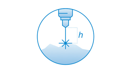
SkyHub software package for True Terrain Following
SPH EngineeringAllows following terrain with very high precision on low altitude using an altimeter sensor. Requires SkyHub on-board computer compatible altimet...
View full detailsOriginal price 4,387.00 USD - Original price 4,387.00 USDOriginal price4,387.00 USD4,387.00 USD - 4,387.00 USDCurrent price 4,387.00 USD -

 Original price 2,964.00 USD - Original price 2,964.00 USDOriginal price2,964.00 USD2,964.00 USD - 2,964.00 USDCurrent price 2,964.00 USD
GeoHammer Pro data processing software
SPH EngineeringSPH Engineering's GeoHammer is a simple to use tool to quickly assess and process GPR (ground penetrating radar) and CSV data from various sensors ...
View full detailsOriginal price 2,964.00 USD - Original price 2,964.00 USDOriginal price2,964.00 USD2,964.00 USD - 2,964.00 USDCurrent price 2,964.00 USD -

GeoHammer data processing software (free version)
SPH EngineeringDownload GeoHammer SPH Engineering's GeoHammer is a simple-to-use tool to quickly assess and process GPR (ground penetrating radar) and CSV dat...
View full details -
GeoHammer Pro data processing software (cloud access)
SPH EngineeringGeoHammer Pro is available not only for download and installation, but also from the cloud on a pay-as-you-go basis. Access GeoCloud SPH Engine...
View full details -

Seequent Oasis montaj
Bentley systems12-month named or shared license. Oasis montaj is industry-standard software for geophysicists to process, filter, and model geophysical survey dat...
View full details


