LiDAR solutions
Transform your surveying capabilities with SPH Engineering's comprehensive LiDAR solutions—the most complete ecosystem for professional drone-based LiDAR operations. Our integrated systems combine industry-leading LiDAR sensors and payloads, as well as professional support to deliver survey-grade 3D data for the most demanding mapping and inspection projects.
Designed for surveyors, engineers, and geospatial professionals, our LiDAR solutions eliminate the complexity of system integration while providing the precision and reliability required for professional applications. From forestry management to infrastructure inspection, our complete solutions ensure you capture the high-density point clouds and accurate terrain models that modern projects demand.
-
 Original price 189.00 USD - Original price 189.00 USDOriginal price189.00 USD189.00 USD - 189.00 USDCurrent price 189.00 USD
UgCS EXPERT Monthly Subscription
SPH EngineeringReasons to choose UgCS Expert Decrease the time spent on LiDAR flight planning (up to 3 times) and let UgCS Expert pay back for itself within 1-...
View full detailsOriginal price 189.00 USD - Original price 189.00 USDOriginal price189.00 USD189.00 USD - 189.00 USDCurrent price 189.00 USD -

 Original price 1,290.00 USD - Original price 1,290.00 USDOriginal price1,290.00 USD1,290.00 USD - 1,290.00 USDCurrent price 1,290.00 USD
UgCS EXPERT Yearly Subscription
SPH EngineeringReasons to choose UgCS Expert Decrease the time spent on LiDAR flight planning (up to 3 times) and let UgCS Expert pay back for itself within 1-...
View full detailsOriginal price 1,290.00 USD - Original price 1,290.00 USDOriginal price1,290.00 USD1,290.00 USD - 1,290.00 USDCurrent price 1,290.00 USD -
 Original price 1,890.00 USD - Original price 1,890.00 USDOriginal price1,890.00 USD1,890.00 USD - 1,890.00 USDCurrent price 1,890.00 USD
UgCS EXPERT Perpetual License
SPH EngineeringReasons to choose UgCS Expert Decrease the time spent on LiDAR flight planning (up to 3 times) and let UgCS Expert pay back for itself within 1-...
View full detailsOriginal price 1,890.00 USD - Original price 1,890.00 USDOriginal price1,890.00 USD1,890.00 USD - 1,890.00 USDCurrent price 1,890.00 USD -
 Original price 490.00 USD - Original price 490.00 USDOriginal price490.00 USD490.00 USD - 490.00 USDCurrent price 490.00 USD
UgCS EXPERT Annual Support & Updates
SPH EngineeringWhen buying an UgCS perpetual license the Support and Updates are included for the first usage year.Starting from the second year since the first a...
View full detailsOriginal price 490.00 USD - Original price 490.00 USDOriginal price490.00 USD490.00 USD - 490.00 USDCurrent price 490.00 USD -

 Original price 890.00 USD - Original price 890.00 USDOriginal price890.00 USD890.00 USD - 890.00 USDCurrent price 890.00 USD
Upgrade UgCS PRO to UgCS EXPERT
SPH EngineeringUpgrade your UgCS PRO perpetual license to UgCS EXPERT perpetual and unlock access to new LiDAR toolset. This upgrade also renews your annual suppo...
View full detailsOriginal price 890.00 USD - Original price 890.00 USDOriginal price890.00 USD890.00 USD - 890.00 USDCurrent price 890.00 USD -
 Original price 2,360.00 USD - Original price 2,360.00 USDOriginal price2,360.00 USD2,360.00 USD - 2,360.00 USDCurrent price 2,360.00 USD
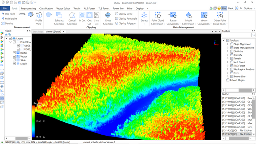
LiDAR360 Forestry module
GreenValley InternationalLeverage LiDAR360 processing software to generate geospatial products from mobile, terrestrial, UAV or airborne systems that meet critical needs of...
View full detailsOriginal price 2,360.00 USD - Original price 2,360.00 USDOriginal price2,360.00 USD2,360.00 USD - 2,360.00 USDCurrent price 2,360.00 USD -
 Original price 4,730.00 USD - Original price 4,730.00 USDOriginal price4,730.00 USD4,730.00 USD - 4,730.00 USDCurrent price 4,730.00 USD
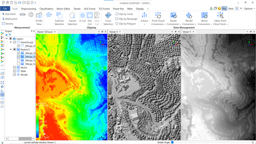
LiDAR360 Framework - base LiDAR360 license
GreenValley InternationalThe LiDAR360 Framework lays the foundation for the entire software suite. With TB-level processing power, the Framework contains tools required for...
View full detailsOriginal price 4,730.00 USD - Original price 4,730.00 USDOriginal price4,730.00 USD4,730.00 USD - 4,730.00 USDCurrent price 4,730.00 USD -
 Original price 2,360.00 USD - Original price 2,360.00 USDOriginal price2,360.00 USD2,360.00 USD - 2,360.00 USDCurrent price 2,360.00 USD
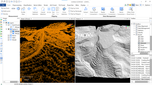
LIDAR360 Terrain Module license
GreenValley InternationalGenerating Terrain Models using LiDAR360. License unlocks group of functions to classify ground points and generate DSM/DTM models. This product i...
View full detailsOriginal price 2,360.00 USD - Original price 2,360.00 USDOriginal price2,360.00 USD2,360.00 USD - 2,360.00 USDCurrent price 2,360.00 USD -
 Original price 415.00 USD - Original price 415.00 USDOriginal price415.00 USD415.00 USD - 415.00 USDCurrent price 415.00 USD
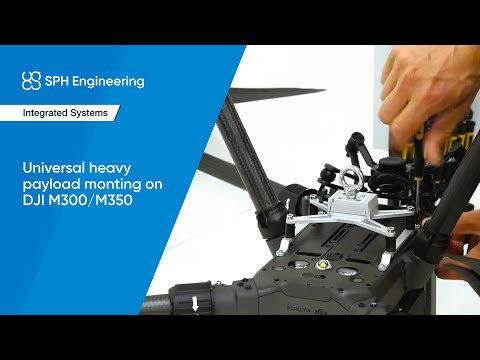
Universal mount for heavy payloads (for DJI M350/M300 RTK drone)
SPH EngineeringUniversal mount for payloads on ropes/cables: echo sounders, water samplers, etc. Also compatible with several other payload types: MagNIMBUS mag...
View full detailsOriginal price 415.00 USD - Original price 415.00 USDOriginal price415.00 USD415.00 USD - 415.00 USDCurrent price 415.00 USD -
 Original price 690.00 USD - Original price 690.00 USDOriginal price690.00 USD690.00 USD - 690.00 USDCurrent price 690.00 USD
Additional Device for UgCS EXPERT Perpetual License
SPH EngineeringAdd an additional device to your UgCS EXPERT Perpetual license. Want to use an office computer for flight planning and a separate field computer...
View full detailsOriginal price 690.00 USD - Original price 690.00 USDOriginal price690.00 USD690.00 USD - 690.00 USDCurrent price 690.00 USD -
 Original price 990.00 USD - Original price 990.00 USDOriginal price990.00 USD990.00 USD - 990.00 USDCurrent price 990.00 USD
Additional Device for UgCS ENTERPRISE Perpetual License
SPH EngineeringAdd an additional device to your UgCS ENTERPRISE Perpetual license. Want to use an office computer for flight planning and a separate field comp...
View full detailsOriginal price 990.00 USD - Original price 990.00 USDOriginal price990.00 USD990.00 USD - 990.00 USDCurrent price 990.00 USD -

 Original price 487.00 USD - Original price 487.00 USDOriginal price487.00 USD487.00 USD - 487.00 USDCurrent price 487.00 USD
Universal mount for heavy payloads (for DJI M400 drone)
SPH EngineeringUniversal mount for payloads on ropes/cables: echo sounders, water samplers, etc. Also compatible with several other payload types: MagNIMBUS mag...
View full detailsOriginal price 487.00 USD - Original price 487.00 USDOriginal price487.00 USD487.00 USD - 487.00 USDCurrent price 487.00 USD


