Magnetometers
SPH Engineering has a portfolio covering all possible applications of airborne (drone-mounted) magnetometers. More importantly, our magnetic survey solutions have been rigorously tested in diverse environments such as Greenland, Iceland, Papua New Guinea, Israel, Chile, the US, and many European countries, including real UXO searches. We have a collection of best-in-class magnetometers and understand their benefits for particular applications.
Discover drone-based magnetometer technology by SPH Engineering »»»
-
Original price 2,964.00 USD - Original price 2,964.00 USDOriginal price2,964.00 USD2,964.00 USD - 2,964.00 USDCurrent price 2,964.00 USD| /
GeoHammer Pro data processing software
SPH EngineeringSPH Engineering's GeoHammer is a simple to use tool to quickly assess and process GPR (ground penetrating radar) and CSV data from various sensors ...
View full detailsOriginal price 2,964.00 USD - Original price 2,964.00 USDOriginal price2,964.00 USD2,964.00 USD - 2,964.00 USDCurrent price 2,964.00 USD| / -
GeoHammer Pro data processing software (cloud access)
SPH EngineeringGeoHammer Pro is available not only for download and installation, but also from the cloud on a pay-as-you-go basis. Access GeoCloud SPH Engine...
View full details -
GeoHammer data processing software (free version)
SPH EngineeringDownload GeoHammer SPH Engineering's GeoHammer is a simple-to-use tool to quickly assess and process GPR (ground penetrating radar) and CSV dat...
View full details -
Seequent Oasis montaj
Bentley systems12-month named or shared license. Oasis montaj is industry-standard software for geophysicists to process, filter, and model geophysical survey dat...
View full details -
Original price 6,414.00 USD - Original price 6,414.00 USDOriginal price6,414.00 USD6,414.00 USD - 6,414.00 USDCurrent price 6,414.00 USD| /
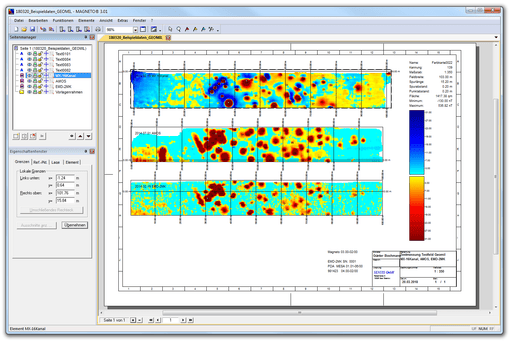
SENSYS MAGNETO® data processing software
SENSYSSENSYS MAGNETO® is a software for the comprehensive analysis and interpretation of data gathered using MagDrone R3, MagDrone R4, or MagDrone R1 mag...
View full detailsOriginal price 6,414.00 USD - Original price 6,414.00 USDOriginal price6,414.00 USD6,414.00 USD - 6,414.00 USDCurrent price 6,414.00 USD| /
Information
Our magnetometer systems have been rigorously field-tested across diverse environments worldwide, from the Arctic conditions of Greenland to the tropical landscapes of Papua New Guinea. This extensive testing ensures reliable performance and consistent data quality regardless of survey location or conditions.
Each system features carefully selected sensors with industry-leading sensitivity, low noise, and robust compensation for platform effects. The result is clean, high-resolution magnetic data that reveals subtle anomalies and patterns crucial for accurate interpretation and decision-making.
By mounting these sophisticated sensors on aerial platforms, our systems enable rapid coverage of large areas while maintaining the data density required for detailed analysis. This combination of speed and precision dramatically reduces project timelines and costs compared to traditional ground-based surveys, especially in difficult terrain or environmentally sensitive areas.
Frequently Asked Questions
What types of magnetometers does SPH Engineering offer for drone integration?
We offer several magnetometer types optimized for different applications, including cesium vapor magnetometers for the highest sensitivity surveys, fluxgate magnetometers for gradient measurements, and potassium magnetometers for environments with significant magnetic noise. Each system is carefully integrated with appropriate UAV platforms to ensure optimal data quality.
What is the typical sensitivity of your drone-mounted magnetometers?
Our systems achieve sensitivities ranging from 0.01 to 0.001 nT, depending on the specific sensor technology used. This exceptional sensitivity allows for the detection of subtle magnetic anomalies that are critical for applications like UXO detection and detailed geological mapping.
How does aerial magnetic surveying compare to traditional ground methods?
Aerial magnetic surveys using our drone-mounted systems typically cover multiple times more area per day than ground crews while maintaining comparable or better data quality. This efficiency translates to significant cost savings, especially for large survey areas or rugged terrain where ground access is limited.
What software solutions are available for processing magnetometer data?
Our systems are compatible with industry-standard geophysical processing software. Additionally, we offer specialized data processing tools designed specifically for aerial magnetic surveys, streamlining the workflow from raw data to final deliverables. More info about GeoHammer »»»
Can your magnetometer systems be integrated with other geophysical sensors?
Yes, our systems are designed with multi-sensor capabilities in mind. We offer integration solutions for combining magnetometers with other sensors such as electromagnetic (EM) systems, radiometric sensors, or photogrammetry equipment.