Bathymetry
SPH Engineering offers MBES (multibeam) and three standard configurations of the SBES (single beam) systems, with single and dual-frequency echo sounders. Typical applications:
- Bathymetry of waterways, lagoons, lakes, ponds, harbors
- Dredging planning and monitoring
- Construction planning
- TSF (Tailing Storage Facilities) monitoring
- Sediments monitoring
Discover drone-based echo sounding technology by SPH Engineering »»»
-


EchoNIMBUS-MBES multibeam echosounder payload
SPH EngineeringEchoNIMBUS-MBES payload includes: Cerulean Surveyor 240-16 MBES sensor head Cerulean Bar30 depth/pressure sensor Foldable mount with housing/fa...
View full details -


EchoNIMBUS-SSS side-scan sonar payload
SPH EngineeringEchoNIMBUS-SSS payload includes: 2x Cerulean Omniscan 450SS side-scan sonar Foldable mount and electronics housing Ethernet switch module Explore...
View full details -

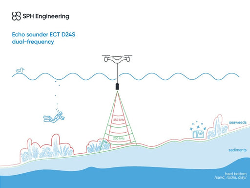
EchoLogger ECT D24S echo sounder
EchoLoggerEchoLogger ECT D24S dual-frequency echo sounder with tilt and temperature sensor, harness, housing, and mountings for the drone. The echo sounder c...
View full details -

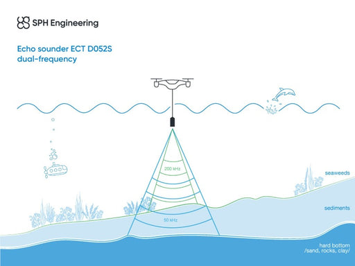
EchoLogger ECT D052S echo sounder
EchoLoggerEchoLogger ECT D052S dual-frequency echo sounder with tilt and temperature sensor, harness, housing, and mountings for the drone. The echo sounder ...
View full details -

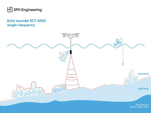
EchoLogger ECT 400S echo sounder
EchoLoggerEchoLogger ECT 400S echo sounder with tilt and temperature sensor, harness, housing, and mountings for the drone. The echo sounder cable is protect...
View full details -


EchoLogger ETF 400S echo sounder
EchoLoggerEchoLogger ETF 400S echo sounder with tilt and temperature sensor, harness, and mountings for the drone. All externally exposed parts, including th...
View full details


