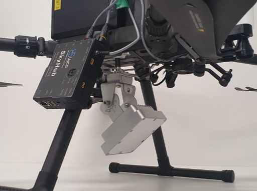
Integrated Systems
Expand your drone capabilities with SPH Engineering's professional integrated systems; the most comprehensive solution for advanced sensor integration and data collection. Our SkyHub onboard computer serves as the central nervous system, enabling seamless integration of diverse sensors with professional UAV platforms while maintaining complete data security and operational reliability.
Designed for professionals in geophysical surveying, hydrographic operations, environmental monitoring, and archaeological research, our integrated systems combine industry-leading sensors with specialized UAV integration. From ground penetrating radar to magnetometers, methane detectors to echo sounders, each system is engineered for precision data collection in challenging environments where traditional methods fall short.
-
Geolux LX-80-AB water level measurement kit
SPH EngineeringGeolux LX-80-AB water level sensor uses radar technology to provide a precise contactless measurement of the distance from the sensor to the water ...
View full details -
Geolux RSS-2-AB water surface velocity measurement kit
SPH EngineeringThe Integrated System with Surface Velocity Radar uses radar technology to provide contactless measurement of surface flow velocity. The radar oper...
View full details
Info
SPH Engineering's integrated systems represent the culmination of years of field experience and professional feedback, offering unmatched capabilities for complex data collection operations. The SkyHub onboard computer provides multiple communication ports supporting any sensor type integration, comprehensive power management, and advanced flight control features that ensure reliable performance in diverse conditions.
Each integrated system includes carefully selected sensors with industry-leading sensitivity and accuracy, paired with professional-grade UAV platforms for optimal performance.
The systems support comprehensive applications including area mapping, corridor surveys, vertical inspections, and terrain-following operations, with specialized tools for geophysical sensors, LiDAR systems, and photogrammetric applications. This versatility makes our integrated systems the preferred choice for professionals requiring precision and reliability in mission-critical operations.
Frequently Asked Questions
What sensors can be integrated with SPH Engineering's systems?
Our SkyHub onboard computer supports any professional sensor through multiple interface options, including Fast Ethernet, RS-232, UART, GPIO, USB, WiFi, and Bluetooth. Common integrations include magnetometers, GPR systems, echo sounders, methane detectors, gamma-ray spectrometers, metal detectors, water samplers, and various altimeter systems.
Which drone platforms are compatible with integrated systems?
Systems integrate seamlessly with professional platforms, including DJI M400, M350 RTK, M300 RTK, Inspired Flight IF1200A/IF800, Harris Aerial H6, Wispr Ranger Pro, and Cube/Pixhawk-based drones with ArduCopter or PX4 firmware. The modular design allows adaptation to various platforms based on payload capacity, flight time, and operational requirements.
How does SkyHub ensure data security and confidentiality?
SkyHub processes all data onboard and offline with no cloud storage or transmission required, ensuring complete data confidentiality. This approach is ideal for sensitive projects, proprietary information, and operations in areas with limited connectivity or strict data handling requirements.
What flight modes are available for integrated sensor operations?
Advanced flight modes include True Terrain Following for maintaining constant elevation above ground, Grasshopper mode for waypoint-based measurements, automated calibration patterns, and obstacle detection for enhanced safety during low-altitude operations.
What training and support is provided for integrated systems?
Comprehensive training covers system setup, sensor calibration, flight planning, data collection protocols, and interpretation. Support includes technical assistance, software updates, and access to professional community resources. Certification programs are available for operators seeking formal qualification in specific sensor technologies.