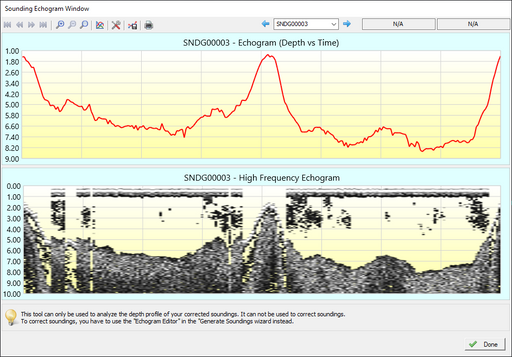
Bathymetry
SPH Engineering offers MBES (multibeam) and three standard configurations of the SBES (single beam) systems, with single and dual-frequency echo sounders. Typical applications:
- Bathymetry of waterways, lagoons, lakes, ponds, harbors
- Dredging planning and monitoring
- Construction planning
- TSF (Tailing Storage Facilities) monitoring
- Sediments monitoring
Discover drone-based echo sounding technology by SPH Engineering »»»
-


EchoNIMBUS-MBES multibeam echosounder payload
SPH EngineeringEchoNIMBUS-MBES payload includes: Cerulean Surveyor 240-16 MBES sensor head Cerulean Bar30 depth/pressure sensor Foldable mount with housing/fa...
View full details -


EchoNIMBUS-SSS side-scan sonar payload
SPH EngineeringEchoNIMBUS-SSS payload includes: 2x Cerulean Omniscan 450SS side-scan sonar Foldable mount and electronics housing Ethernet switch module Explore...
View full details -

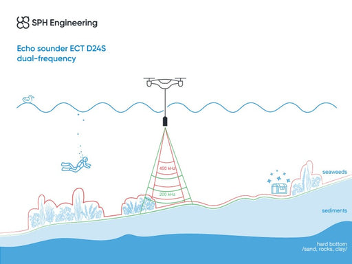
EchoLogger ECT D24S echo sounder
EchoLoggerEchoLogger ECT D24S dual-frequency echo sounder with tilt and temperature sensor, harness, housing, and mountings for the drone. The echo sounder c...
View full details -

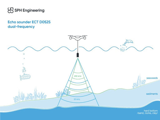
EchoLogger ECT D052S echo sounder
EchoLoggerEchoLogger ECT D052S dual-frequency echo sounder with tilt and temperature sensor, harness, housing, and mountings for the drone. The echo sounder ...
View full details -

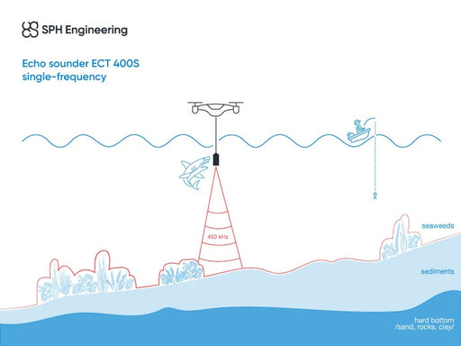
EchoLogger ECT 400S echo sounder
EchoLoggerEchoLogger ECT 400S echo sounder with tilt and temperature sensor, harness, housing, and mountings for the drone. The echo sounder cable is protect...
View full details -


EchoLogger ETF 400S echo sounder
EchoLoggerEchoLogger ETF 400S echo sounder with tilt and temperature sensor, harness, and mountings for the drone. All externally exposed parts, including th...
View full details -
 Original price 6,402.00 USD - Original price 6,402.00 USDOriginal price6,402.00 USD6,402.00 USD - 6,402.00 USDCurrent price 6,402.00 USD
SkyHub software package for echo sounder
SPH EngineeringSoftware package to support single and dual-frequency echo sounders. Includes firmware for SkyHub on-board computer and companion application for U...
View full detailsOriginal price 6,402.00 USD - Original price 6,402.00 USDOriginal price6,402.00 USD6,402.00 USD - 6,402.00 USDCurrent price 6,402.00 USD -
 Original price 2,370.00 USD - Original price 2,370.00 USDOriginal price2,370.00 USD2,370.00 USD - 2,370.00 USDCurrent price 2,370.00 USD
Eye4Software B.V. Hydromagic Survey
Eye4SoftwareComputer bound license (two computers maximum). Hydromagic Survey is a professional hydrographic survey package, which can be used to map depth are...
View full detailsOriginal price 2,370.00 USD - Original price 2,370.00 USDOriginal price2,370.00 USD2,370.00 USD - 2,370.00 USDCurrent price 2,370.00 USD -

 Original price 355.00 USD - Original price 355.00 USDOriginal price355.00 USD355.00 USD - 355.00 USDCurrent price 355.00 USD
Eye4Software B.V. Hydromagic Survey Maintenance / Support renewal for 1 year
Eye4SoftwareAnnual support and update pack for Hydromagic Survey.Provide access to any technical inquiries as well as access to new versions.
Original price 355.00 USD - Original price 355.00 USDOriginal price355.00 USD355.00 USD - 355.00 USDCurrent price 355.00 USD -


BeamworX Suite
BeamworXBeamworX Suite license for 1 year. Recommended for EchoNIMBUS-MBES data processing. Includes licenses for AutoClean, AutoPatch, NavAQ modules. Aut...
View full details -
 Original price 165.00 USD - Original price 165.00 USDOriginal price 165.00 USD165.00 USD165.00 USD - 165.00 USDCurrent price 165.00 USD
Self-study course - Bathymetric Data Collection using Drone (BATHY-1)
LearnWorldsThe course provides a comprehensive overview of the fundamentals of bathymetry survey planning, data processing, and data interpretation. The cour...
View full detailsOriginal price 165.00 USD - Original price 165.00 USDOriginal price 165.00 USD165.00 USD165.00 USD - 165.00 USDCurrent price 165.00 USD -
 Original price 165.00 USD - Original price 165.00 USDOriginal price 165.00 USD165.00 USD165.00 USD - 165.00 USDCurrent price 165.00 USD
Self-study course - Bathymetric Data Processing (BATHY-2)
LearnWorldsThe course provides a comprehensive overview of the fundamentals of bathymetry survey planning, data processing, and data interpretation. The price...
View full detailsOriginal price 165.00 USD - Original price 165.00 USDOriginal price 165.00 USD165.00 USD165.00 USD - 165.00 USDCurrent price 165.00 USD -
 Original price 475.00 USD - Original price 475.00 USDOriginal price 475.00 USD475.00 USD475.00 USD - 475.00 USDCurrent price 475.00 USD
Practical Exam & Certification - Bathymetry
LearnWorldsThe test verifies hands-on skills and experience in gathering, processing, and understanding data using systems provided by SPH Engineering. How it...
View full detailsOriginal price 475.00 USD - Original price 475.00 USDOriginal price 475.00 USD475.00 USD475.00 USD - 475.00 USDCurrent price 475.00 USD -
 Original price 465.00 USD - Original price 465.00 USDOriginal price 465.00 USD465.00 USD465.00 USD - 465.00 USDCurrent price 465.00 USD
Practical exam and certification - MBES Bathymetry
LearnWorldsCertification verifies hands-on expereince in gathering, processing and interpreting MBES bathymetry data using EchoNIMBUS-MBES sensor system. By t...
View full detailsOriginal price 465.00 USD - Original price 465.00 USDOriginal price 465.00 USD465.00 USD465.00 USD - 465.00 USDCurrent price 465.00 USD -
 Original price 1,002.00 USD - Original price 1,002.00 USDOriginal price1,002.00 USD1,002.00 USD - 1,002.00 USDCurrent price 1,002.00 USD
Trainer-led course - Bathymetric Data Collection using Drones (BATHY-1)
SPH EngineeringOnly one of its kind training to learn how to perform bathymetric surveys with echo sounders integrated with a drone.Students should have the knowl...
View full detailsOriginal price 1,002.00 USD - Original price 1,002.00 USDOriginal price1,002.00 USD1,002.00 USD - 1,002.00 USDCurrent price 1,002.00 USD -
Original price 1,002.00 USD - Original price 1,002.00 USDOriginal price1,002.00 USD1,002.00 USD - 1,002.00 USDCurrent price 1,002.00 USD
Trainer-led course - Bathymetric Data Processing (BATHY-2)
SPH EngineeringOnly one of its kind training to learn how to process bathymetric data gathered with echo sounders integrated with a drone. Training is deducated f...
View full detailsOriginal price 1,002.00 USD - Original price 1,002.00 USDOriginal price1,002.00 USD1,002.00 USD - 1,002.00 USDCurrent price 1,002.00 USD -
 Original price 1,435.00 USD - Original price 1,435.00 USDOriginal price1,435.00 USD1,435.00 USD - 1,435.00 USDCurrent price 1,435.00 USD
Trainer-led course - UgCS Area Scan and True Terrain Following (TFF) Missions
SPH EngineeringTraining is recommended for users of UgCS software and Integrated Systems who already have basic knowledge of UgCS. Training can be provided at th...
View full detailsOriginal price 1,435.00 USD - Original price 1,435.00 USDOriginal price1,435.00 USD1,435.00 USD - 1,435.00 USDCurrent price 1,435.00 USD -
 Original price 321.00 USD - Original price 321.00 USDOriginal price321.00 USD321.00 USD - 321.00 USDCurrent price 321.00 USD
Echosounder USB converter
SPH EngineeringA converter (adapter) for connecting an echosounder with a Switchcraft connector to a computer's USB port. Useful for testing, configuration, firmw...
View full detailsOriginal price 321.00 USD - Original price 321.00 USDOriginal price321.00 USD321.00 USD - 321.00 USDCurrent price 321.00 USD -
 Original price 415.00 USD - Original price 415.00 USDOriginal price415.00 USD415.00 USD - 415.00 USDCurrent price 415.00 USD
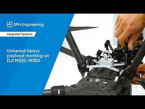
Universal mount for heavy payloads (for DJI M350/M300 RTK drone)
SPH EngineeringUniversal mount for payloads on ropes/cables: echo sounders, water samplers, etc. Also compatible with several other payload types: MagNIMBUS mag...
View full detailsOriginal price 415.00 USD - Original price 415.00 USDOriginal price415.00 USD415.00 USD - 415.00 USDCurrent price 415.00 USD -

 Original price 487.00 USD - Original price 487.00 USDOriginal price487.00 USD487.00 USD - 487.00 USDCurrent price 487.00 USD
Universal mount for heavy payloads (for DJI M400 drone)
SPH EngineeringUniversal mount for payloads on ropes/cables: echo sounders, water samplers, etc. Also compatible with several other payload types: MagNIMBUS mag...
View full detailsOriginal price 487.00 USD - Original price 487.00 USDOriginal price487.00 USD487.00 USD - 487.00 USDCurrent price 487.00 USD


